

Arizona, famed for its towering saguaros and breathtaking canyon landscapes, is not just a destination for winter tourists; it is a critical migratory crossroads for North American avian life. To truly understand the secret routes, stopover habits, and ultimate fates of the millions of birds passing through the state, scientists rely on more than just binoculars. They rely on the silent, persistent watchfulness of the MoTus Wildlife Tracking System—a network of high-tech radio telemetry towers acting as an invisible net across the desert sky.
The MoTus system in Arizona is a game-changer, transforming birdwatching and conservation from an act of chance observation into a science of precise, continuous data collection.
What is the MoTus System?
The term MoTus is Latin for "movement," which perfectly describes the system's function. It is a massive, international collaborative network that uses automated radio telemetry to track the movement of animals, primarily birds, bats, and large insects, that have been fitted with tiny radio transmitters.
1. The Tiny Technology: Nanotags
The system relies on "nanotags"—miniature, lightweight radio transmitters. These devices are so small (some weighing as little as 0.2 grams, less than a paperclip) that they can be safely affixed to small songbirds like warblers and hummingbirds without interfering with their flight or migration. Each nanotag emits a unique, coded radio frequency signal.

2. The Infrastructure: The Tower Network
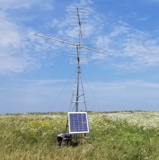
The MoTus Towers are essentially tall antennas equipped with automated receivers and data logging equipment. When a tagged bird flies within range (which can vary from a few kilometers up to 15 kilometers, depending on topography and tag power), the tower receiver instantly identifies the bird's unique ID, the precise date, and the time of detection.
3. Arizona’s Critical Role
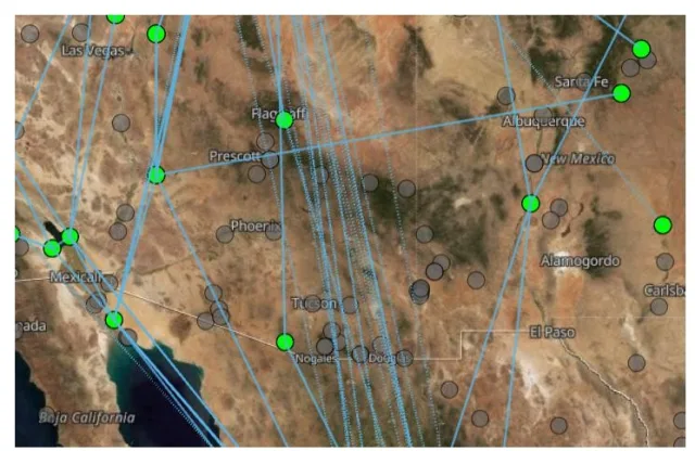
Arizona’s placement within the network is vital. It spans a key area for two major migration corridors: the Pacific Flyway and the Central Flyway. Towers are strategically placed across diverse habitats, from the riparian corridors along the Santa Cruz River and the Gila River to mountain ranges like the Huachuca and Santa Rita mountains, allowing researchers to monitor the flow of migrants using the state as a crucial link between Mexico and the northern breeding grounds.
How MoTus Helps Conservation Organizations
For conservation groups, MoTus provides the missing pieces of the puzzle that traditional banding and sighting methods could never reveal. The data gathered informs every aspect of habitat protection and policy development:
1. Identifying Critical Stopover Habitats
Previously, scientists could confirm a bird was in an area but couldn't tell if it stayed for a day or two weeks. MoTus data provides precise dwell times. Conservationists can now identify specific canyons, urban parks, or stretches of river that birds rely on for critical refueling stops. This allows organizations to:
Prioritize Land Acquisition: Directing limited funds to protect the most essential "gas stations" along the migratory route.
Target Restoration: Focusing habitat restoration efforts (e.g., planting native nectar plants for hummingbirds or cottonwood trees for warblers) in areas proven to be high-use sites.
2. Pinpointing Mortality and Survival
MoTus helps answer crucial questions about population decline. If a bird is tagged in New York and its signal is suddenly lost over a specific housing development in Arizona, researchers can investigate that area for known threats (like communication towers, solar farms, or high-risk windows). This data helps organizations lobby for bird-safe policy changes in areas proven to be collision hotspots.
3. Informing Climate Change Modeling
The data collected year after year reveals subtle but measurable shifts in migration timing and route fidelity. MoTus provides the empirical evidence needed to understand how climate change is affecting avian phenology (the timing of natural events). Conservation groups use this information to create effective climate adaptation strategies for vulnerable species.
How MoTus Empowers Birdwatchers
While the system is a scientific tool, its publicly accessible data platform fundamentally enhances the experience and contribution of birdwatchers.
1. Route Predictability and Targeting
Birders can access the MoTus public database (via the Motus website) to view the general movement patterns of tagged species. For the highly engaged birder, this data can inform where to focus their efforts:
Knowing that a large number of tagged Western Tanagers just hit a tower cluster in the Patagonia area suggests that migration is peaking, guiding birders to that region.
It can confirm which specific valleys or mountain passes are used as navigational funnel points.
2. Connecting with the Species
When a birder sees a tagged bird (a bird with a small antenna glued to its back feathers or leg), they can potentially look up the tag ID on the MoTus system. This offers a deeply personal connection, revealing the individual bird's entire journey: “That Bullock’s Oriole I just saw in my backyard feeder was tagged last fall in Alberta and spent the winter in Jalisco, Mexico.”
3. The Thrill of the Detection
Though few birders have their own full tower, many dedicated birding groups or centers (like those in Southeast Arizona) partner with the MoTus team to install localized receiving stations. Birders can then track local detections in real-time or near-real-time, giving them a high-tech "sighting list" that includes birds physically present but visually hidden.
How To Get Involved
1. Host or Support a MoTus Station (High Impact)
The most direct way to get involved is by helping to expand and maintain the physical network of tracking towers. Around 20 states now have MoTus towers and that is expanding all the time. Check the website for information on being involved with the project in your area.
Host a Station: If you own property in a strategically important area (often a high point with an unobstructed view of the horizon for several kilometers) and are willing to commit to a 5-10 year agreement, you can host a MoTus tower.
Requirements: A suitable site usually needs a clear line-of-sight, minimal radio interference, and access to power (AC or reliable solar exposure).
The Benefit: You contribute to a global research initiative right from your property, and the costs for equipment, installation, and maintenance are usually covered by the collaborating researcher or organization.
Support a Station: Motus stations are expensive, with typical costs for equipment and setup estimated around $7,500 USD (though this varies widely). You can help fund a station in a critical gap area.
How: Donate to Birds Canada (which manages the system) or contact regional Motus collaborations (like the Western Working Group or Northeast Motus Collaboration) to sponsor a station.

2. Utilize MoTus in Research (For Professionals/Students)
If you are a biologist, ecologist, or student, you can integrate MoTus data into your own work.
Become a Collaborator: Researchers can purchase and deploy their own nanotags on species they are studying. When these animals fly past any tower in the global network, the data is automatically collected and shared, exponentially increasing the scope of your project.
Access the Data: The Motus public database is a treasure trove of movement information. You can use the existing data (after understanding the collaboration policy) for analyses on migratory routes, stopover behavior, and survival rates.
3. Education and Outreach (For Teachers and Enthusiasts)
You don't need to be a scientist or a landowner to spread the word and use the data.
Incorporate into Education: Use the concept of automated telemetry to teach students about bird migration, conservation biology, and technology. Motus provides various educator resources and materials to help build curriculum around the system.
Promote the Project: Share the significance of the MoTus network through social media, nature center talks, or local bird club meetings. Use the public data to illustrate migration stories relevant to your region.
4. General Support and Volunteering
Donate: Contribute to Birds Canada to help fund the overall maintenance, technology development, and database management for the global system. This ensures the foundational technology remains viable for all collaborators.
Assist Collaborators: Check with your regional birding organizations (like your local Audubon chapter or a university research lab) that are known to use MoTus. They may need volunteers for tasks such as fieldwork support, assisting with tagging (which requires special training), or helping with the manual download of data from remote stations.
To start, the best step is to visit the official Motus Wildlife Tracking System website (Motus.org) and navigate to their "Get Involved" section to see specific regional needs and contact information.
Wrapping Up
The MoTus towers of Arizona are more than just research stations; they are sentinels ensuring the survival of migratory birds. By turning the sky into a massive, data-rich tracking field, they provide conservationists with the insight needed to save habitats and give birdwatchers an unprecedented window into the epic journeys that crisscross the American Southwest.
